Szybkość i skuteczność – drony pozwalają na szybkie dotarcie do odległych lub trudno dostępnych miejsc, co pozwala na szybkie i skuteczne przeprowadzenie inspekcji szkód łowieckich.
Dokładność – drony są wyposażone w zaawansowane kamery, co pozwala na dokładne zarejestrowanie i udokumentowanie szkód, w tym ich rozmiaru (pomiar powierzchni) i charakteru.
Analiza szkód na dużym obszarze – drony umożliwiają przeprowadzenie inspekcji szkód łowieckich na dużych obszarach, co pozwala na dokładne zidentyfikowanie obszarów z największymi szkodami.
Nasze typowe działania w ramach inspekcji oraz inwentaryzacji szkód łowieckich obejmują:
1. Dokumentacja fotograficzna lub filmowa; 2. Ortofotoplan obszarów dotkniętych szkodami łowieckimi (nalot fotogrametryczny); 3. Wektoryzacja – opomiarowanie obszarów uszkodzonych; 4. Raport jakościowy oraz ilościowy;
Opracowanie zwektoryzowane (pozwalające na pomiar obszarów uszkodzonych) stanowi obiektywne narzędzie dla wszystkich stron postępowania. Gwarantuje szybsze dojście do porozumienia w kwestii wysokości odszkodowania niż szacowanie w oparciu o wizję lokalną z poziomu gruntu.
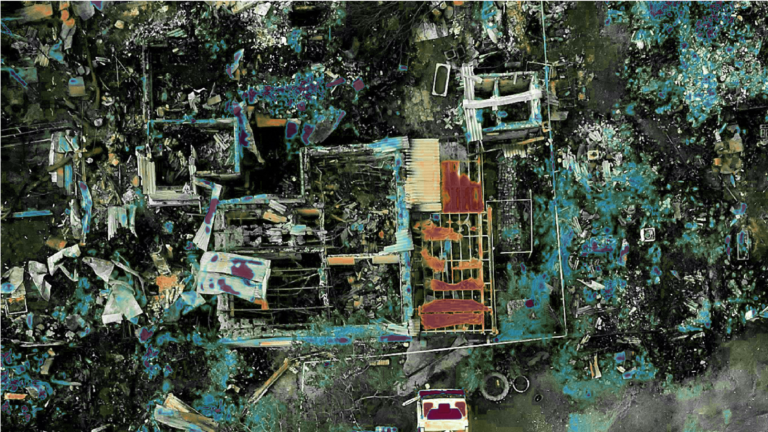
Inspekcje i inwentaryzacje pogorzelisk
Szybkość i dokładność – drony mogą przeprowadzać inspekcje pogorzelisk znacznie szybciej niż ludzie. Ponadto, dzięki wyposażeniu w kamery i sensory, mogą dostarczać bardzo dokładnych informacji o obszarach, które uległy zniszczeniu.
Bezpieczeństwo – inspekcja pogorzelisk może być niebezpieczna dla ludzi, ze względu na niestabilne elementy budowlane, pożary wtórne, itp. Wykorzystanie dronów umożliwia bezpieczne przeprowadzenie inspekcji bez narażania ludzi na niebezpieczeństwo.
Dostępność – drony są w stanie dotrzeć do miejsc, do których ludzie nie są w stanie się dostać ze względu na wysokość, niebezpieczne gazy, niestabilność konstrukcji.
Typowe działania w ramach inspekcji i inwentaryzacji pogorzelisk obejmują:
1. Dokumentacja fotograficzna lub filmowa; 2. Ortofotoplan pogorzeliska (nalot fotogrametryczny): 3. Opcjonalnie wykonanie poglądowego modelu 3D; 4. Wektoryzacja – opomiarowanie obszarów uszkodzonych lub zniszczonych; 5. Raport jakościowy oraz ilościowy;